This chapter provides a description of the project and forms the basis for the environmental assessment provided in this Environmental Statement (ES). Further information can be found in the appendices section of this digital ES.
The effects of the project have been assessed throughout the ES based on what is likely. For example, construction information is presented as the ‘likely case’. A number of measures which would reduce or avoid adverse environmental effects arising have been included as part of the project design. Details of these measures are provided in this chapter and set out in each topic chapter. This chapter, together with the subsequent topic chapters, provide the data required to identify and assess the main and likely significant effects of the project in accordance with Regulation 18 and Schedule 4 of the EIA Regulations.
This chapter provides a description of the site and the key components of the project, including an overview of the approach to construction.
Site Location
This section describes the site location, including its surroundings. It also describes any previous planning applications on the site or nearby.
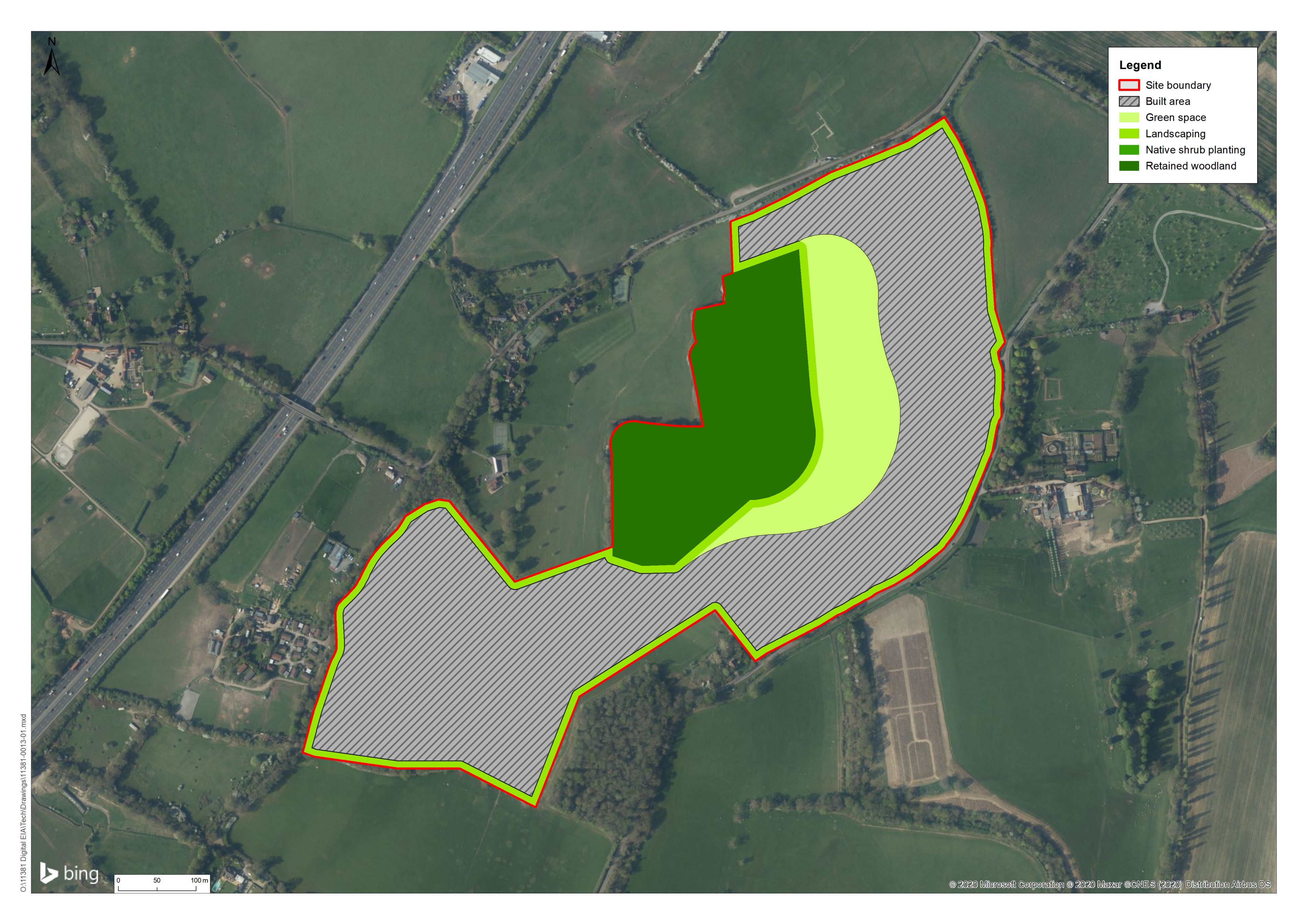
The portion of the project site proposed for development measures approximately 20 a in size with an additional area of approximately 10 ha of green space proposed in the eastern portion of the project site. The total site area for the project is therefore approximately 30 hectares. A site location plan is provided at below through an interactive map and in the Figures section as PDF versions.
Geology and Topography
The majority of the bedrock underlaying the site is Upper Greensand Formation, a calcareous standstone and siltstone. Overlying the bedrock is a series of alluvium and river terrace deposits.
The site slopes from a high point of approximately 46.5 meters above ordnance datum (AOD) in the north west corner to 17.5 meters AOD in the south east. The ordnance survey (OS) mapping and topographic data confirm two watercourses on site.
Site History
The majority of the site has historically been in agricultural use and consists of a number of agricultural fields segmented by hedgerows and treelines. Early OS mapping an area of woodland in the northern section of the site which has since been removed. Two agricultural buildings were also present in the south western section of the site which are no longer present.
Planning Context
The site is located within the administrative area of Stayous.
Key Components
dwellings created
m² of commercial space
m² of green space
new car parking spaces
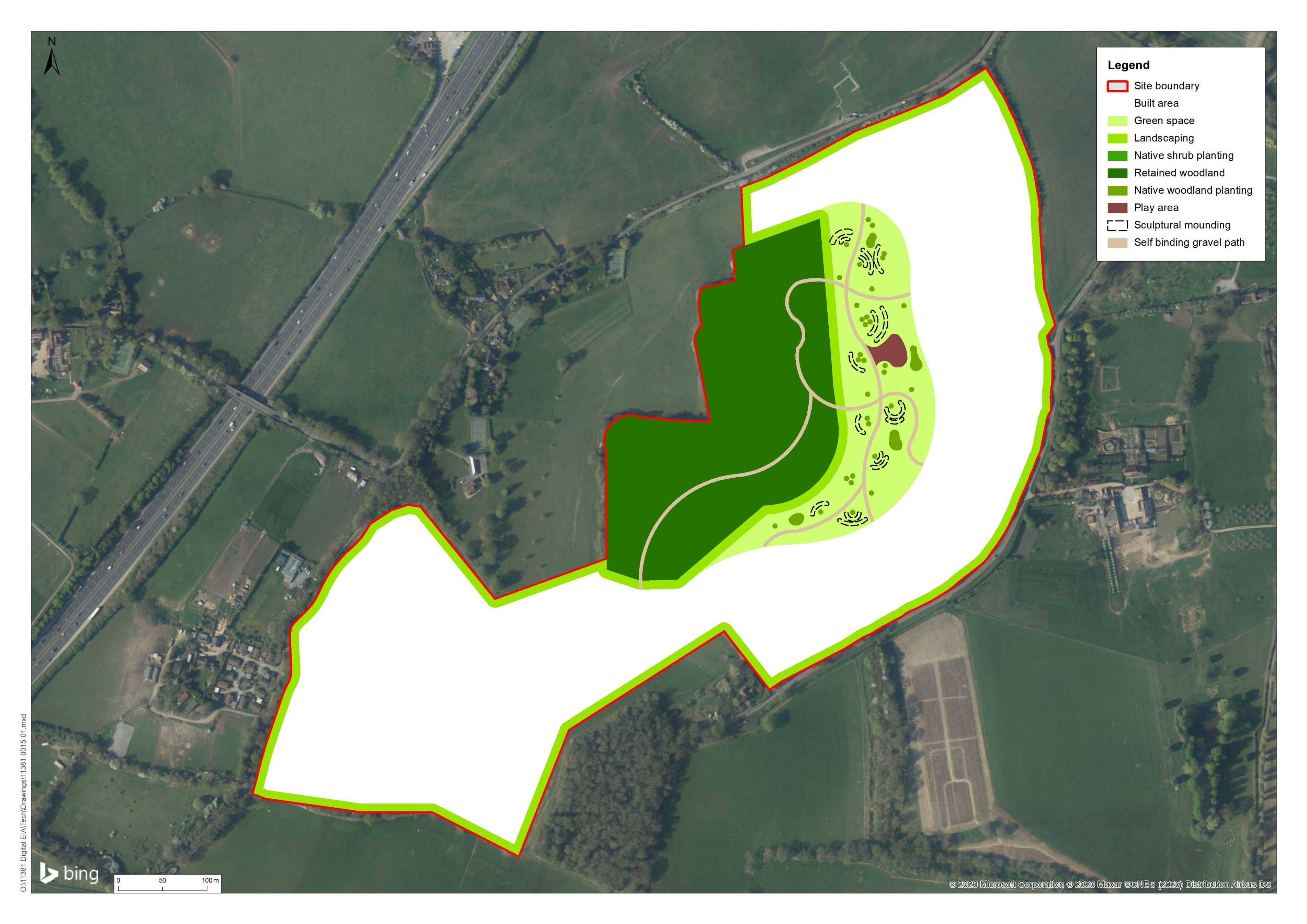
A masterplan of the project is provided below in Figure 2.2 and a green space masterplan in Figure 2.3. Further details of the key components are provided below.
Access and Parking
There would be three main points of vehicular access to the project site: from the north, south and west.
Residential parking has been incorporated into the masterplan in line with the Local District Council Parking Strategy. Pedestrian and cycle connections to the wider highway and Public Right of Way (PRoW) network are also included in the masterplan.
In addition to the connections by foot/cycle to the existing network outlined above, footways/cycleways within the site would also be provided.
Off street parking and on street parking including would be provided.
Transport Management
The internal layout of the site has been carefully considered to ensure that traffic generated by the project would be evenly distributed amongst the three proposed points of access
As outlined above, a network of footway and cycleways would be provided to allow movement of pedestrian and cyclists throughout the site. The footway/cycleways would be connected to existing and proposed facilities and would promote the use of sustainable modes of transport.
A Residential Travel Plan would be produced for the project site which would provide information regarding future residents’ travel patterns and would include details of public transport and walking/cycling routes.
Appearance and Design
The designs and styles of homes that surround the development vary. One of the key themes of the site and its design ethos was to create a high quality and low/medium density development which offers pleasant private gardens and plentiful public open spaces (which will be landscaped) within the sites interior.
This will work in composite with the wider new multi user routes to the east, west and south (as well as comprehensively within the sites interior) to encourage walking and cycling in all directions and to offer ‘travel choices’ (and to encourage health and well-being). It also assists to connect into existing bus stops and routes. Therefore, the sites design and its integration into a ‘travel choice’ has been a key and deliverable ambition.
The design process has worked closely with the Local Planning Authority and the wider client consultant team; ensuring that all relevant material considerations have been closely analysed and covering topics such as trees, ecology, drainage and flood risk.
Working with the existing context and character of the area the design team have taken traditional design ques from English house building during the first 30 years of the 20th century to create homes that are classic and traditional in appearance.
Landscape and Open Space Strategy
Open space would be provided throughout the site, particularly in the centre of the site and surrounding the commercial development. The landscape strategy seeks to promote an attractive and suitable space for proposed residents and to ensure its visual impact is minimised and the landscape character of the site and its surroundings is strengthened through the inclusion of open space, along with:
In addition, the 10 hectare green space would provide further open space and comprise the following habitats and landscape elements:
A Management Plan and Monitoring Strategy has been produced and submitted as part of the application. The strategy has been produced to demonstrate how the green space will comply with relevant requirements and sets out details of the layout, establishment, aftercare and long term management. Management of the green space would include but not be limited to:
All maintenance and management of soft landscape areas within the SANG would be undertaken by a suitably qualified landscape management contractor on behalf of the Applicant. The delivery of the SANG would be controlled by the Section 106 agreement.
Drainage and Flood Risk
The design of the proposed drainage infrastructure would ensure that greenfield runoff rates would be maintained (including a 40% freeboard to adapt to climate change) in order to mimic the existing situation and ensure that the risk of flooding downstream of the project is not increased. A Flood Risk Assessment (FRA) and drainage strategy have been developed to assess the control and regulation of surface water runoff required within the site boundary in order to restrict runoff to greenfield rates. The strategy includes SuDS to attenuate surface water and allow controlled pollution treatment and discharge to the existing watercourse on site. The drainage systems would be designed so that surface water runoff from the site is contained within the drainage network, with no flooding for all storms up to, and including the 1 in 30 year event.
The indicative SuDS solution is proposed to be delivered through a series of attenuation ponds/detention basins located throughout the site.
The project would require street lighting. A full lighting strategy would be submitted to the Council for agreement (via planning condition) prior to occupation of the site.
The lighting strategy would aim to ensure adequate safety and security for residents while minimising energy use and light pollution and creating an attractive environment. The lighting strategy would be designed in accordance with the Institute of Lighting Professionals Guidance Notes for the Reduction of Obtrusive Light GN01:2011. The strategy would include measures to ensure the minimum practicable height lighting columns and would be designed to reduce visual glare.
Sustainability
The project has been designed taking into account the findings of the environmental assessment process and based on the principles of good design. Key sustainability measures that form part of the project include the provision of:
Vulnerability to Accidents and Disasters
The EIA Regulations require consideration of the effects on the environment deriving from the vulnerability of the project to risks from major accidents and/or disasters, where these are relevant to the project concerned.
This section considers the potential accidents and disasters that could affect the project or the environment. However, it is stressed that such events are not considered likely. A summary of the potential risks associated with major accidents and disasters relevant to specific environmental topic would be described in other chapters of the ES not presented here in this demonstration site.
Summary of Key Parameters
The table below provides a summary of the key parameters which have formed the basis for the assessment of effects.
| Key Parameter | |
|---|---|
| Total site area | 30 ha |
| Total number of dwellings/floor space | 500 |
| Commercial floor space | 500 m² |
| Maximum dwelling height | two storey |
| Area of built development | 20 ha |
| Area of public open space | 10 ha |
| Surface drainage infrastructure | 10,000 m² |
| Car parking provision | 500 spaces |
The details of construction methods, timing and phasing are necessarily broad at this stage. The limits of the assessment; however, have been set sufficiently wide to allow a robust assessment to be undertaken of a reasonable worst case scenario.
The timing of the project would be dependent on securing planning permission and the discharge of any planning conditions. It is anticipated that the construction of the project would commence in 2021. The indicative construction programme sets out a programme of approximately nine years with an approximate build rate of 50 dwellings per annum.
The broad sequence of construction activities is likely to be:
Construction would be undertaken in accordance with a Code of Construction Practice (CoCP) to be completed prior to construction. The CoCP would set out the key management measures that contractors would be required to adopt and implement. Measures required to be included in the CoCP, based on the findings of the EIA process, are set out in the topic chapters of this ES. These measures include strategies and control measures for managing the potential environmental effects of construction and limiting disturbance from construction activities as far as reasonably practicable.
The CoCP would form the basis of more detailed plans and method statements, including a Construction Environmental Management Plan (CEMP), to be prepared during the pre-construction period once a Principal Contractor has been appointed.
In order to avoid or reduce the environmental effects, a number of measures have been designed into the project. Details of these would be found within each topic chapter of the ES. These measures are summarised below, click the tabs to see more information.
Construction would be undertaken in accordance with a CoCP. The CoCP would form the basis of more detailed plans and method statements, to be prepared during the pre-construction period once the Principal Contractor has been appointed.
General construction mitigation measures would ensure that light spill would be limited to construction working hours to reduce impacts to nocturnal species.
Standard best practice dust-suppression methods would be used throughout the construction phase to control any impacts as a result of dust settlement in habitats and species.
Lorem ipsum dolor sit amet, consectetur adipisicing elit. Soluta consequatur animi fugit iste distinctio eaque officia ducimus sit accusantium aliquid itaque delectus, numquam dolorum corrupti, laborum ratione est, harum repellendus.
Lorem ipsum dolor sit amet, consectetur adipisicing elit. Non atque temporibus accusantium tempora quas unde, voluptates adipisci provident? Accusantium eligendi similique distinctio est vel magnam tempora, maiores ipsum odio ducimus.
Lorem ipsum dolor sit amet, consectetur adipisicing elit. Cum, id qui excepturi quidem cumque ipsum mollitia. Repellendus ab, aliquid molestias minus dolores reiciendis porro voluptatibus dolore, qui quod repellat ea?
Lorem ipsum dolor sit amet, consectetur adipisicing elit. Earum id provident ea quae explicabo aperiam praesentium distinctio veritatis natus maiores dicta numquam error nemo, corrupti dolore molestias quia esse adipisci!